Category: Digital

Digital

Volumetric (3D) Recording

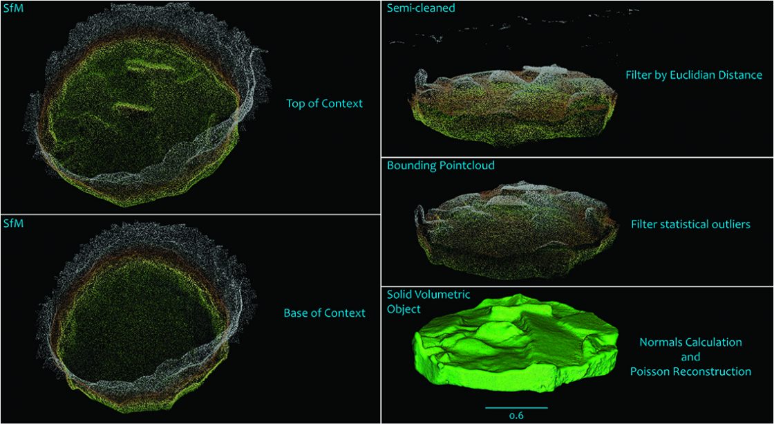
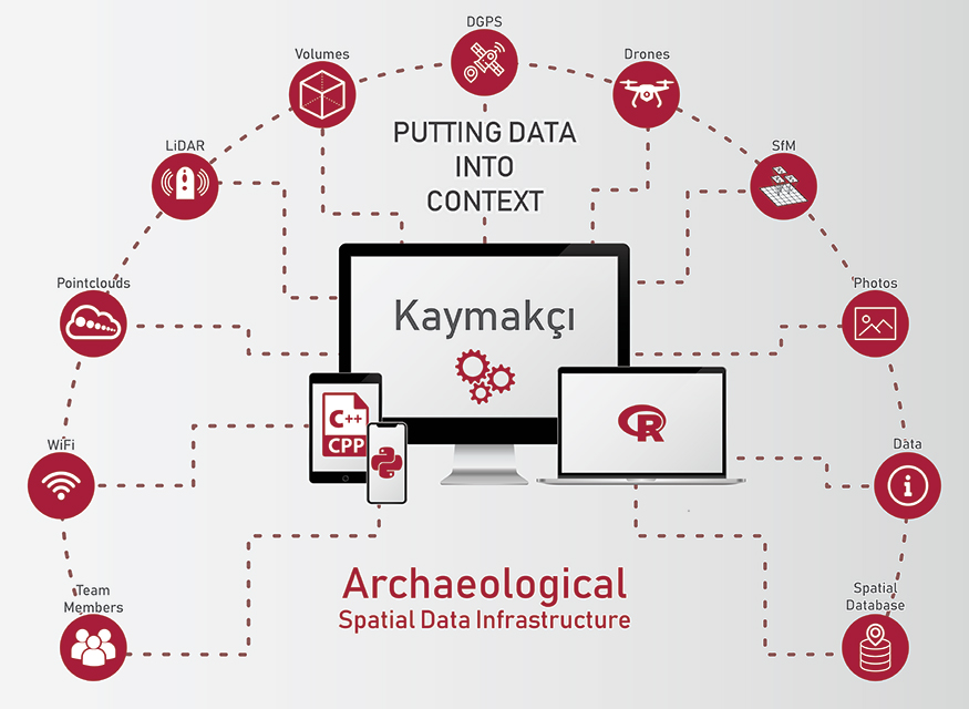
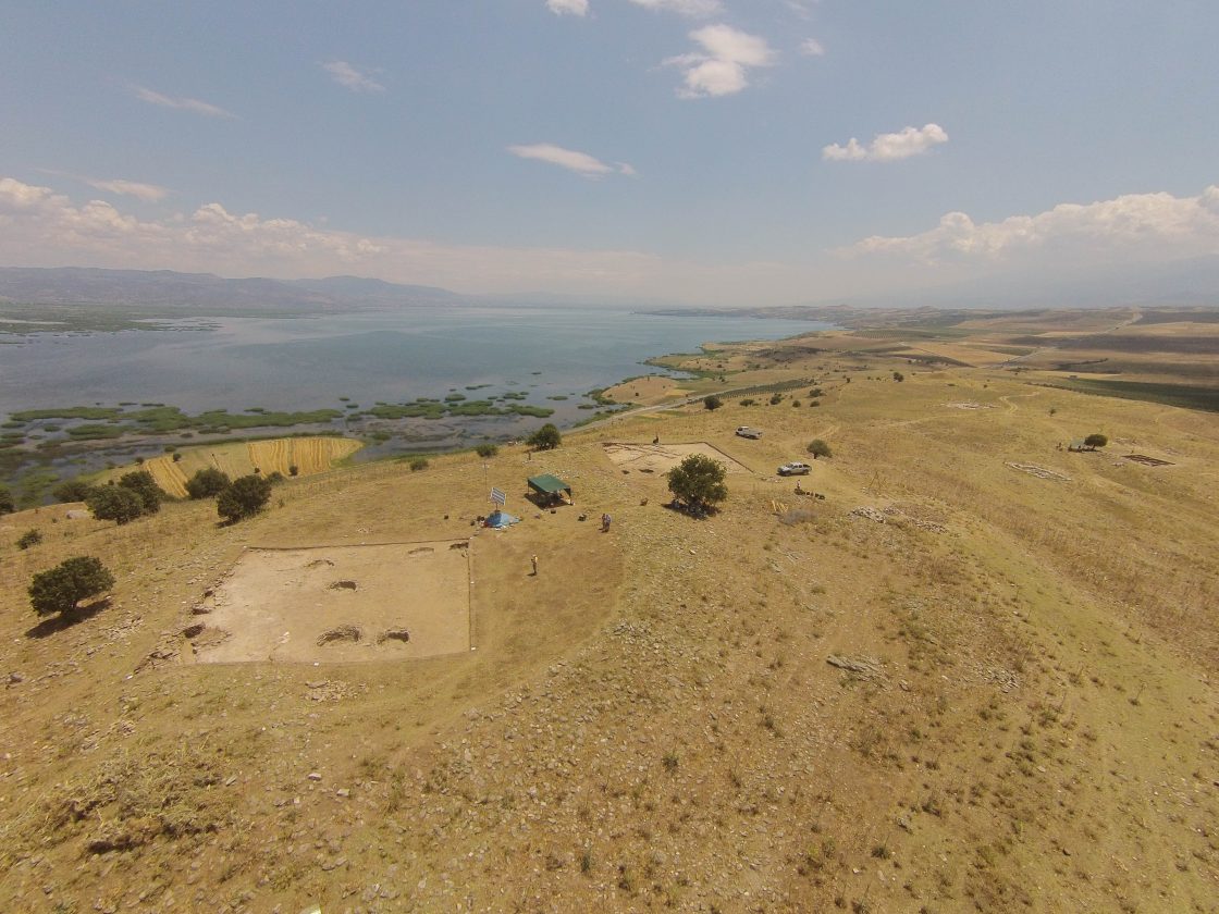
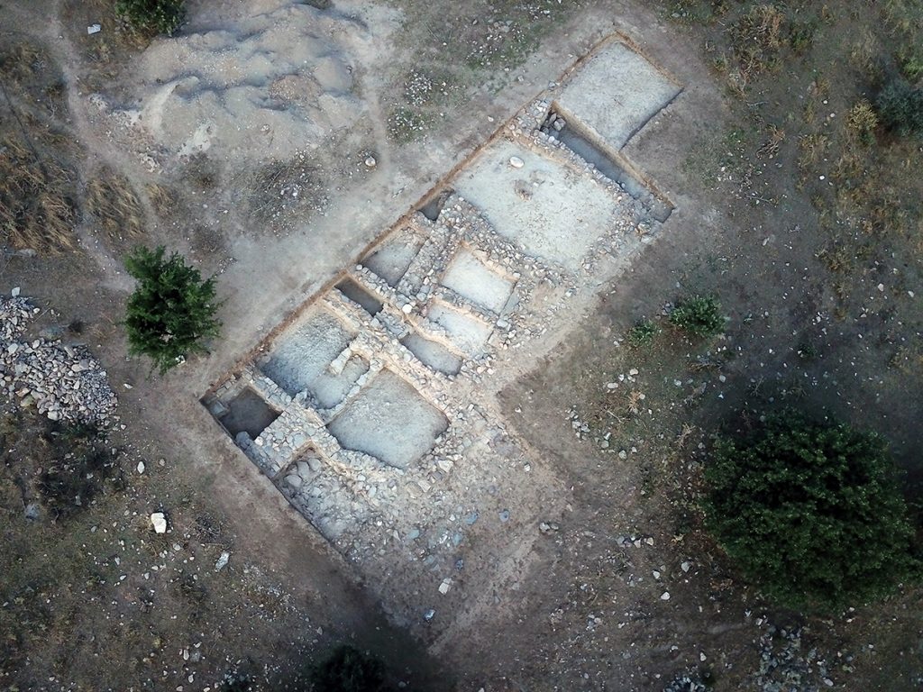
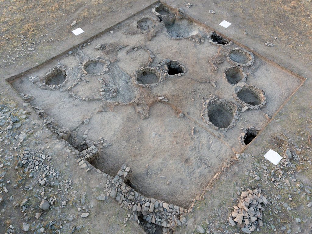
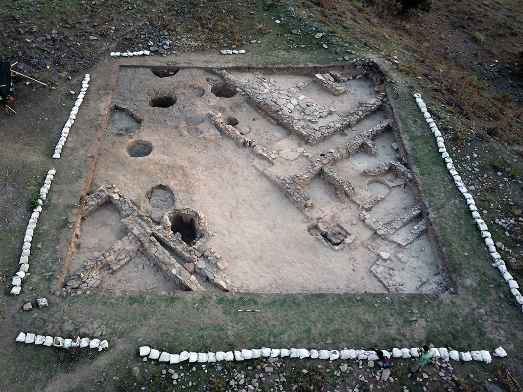
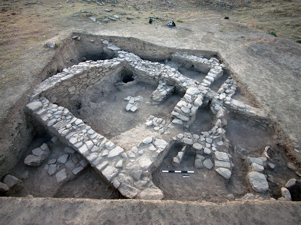
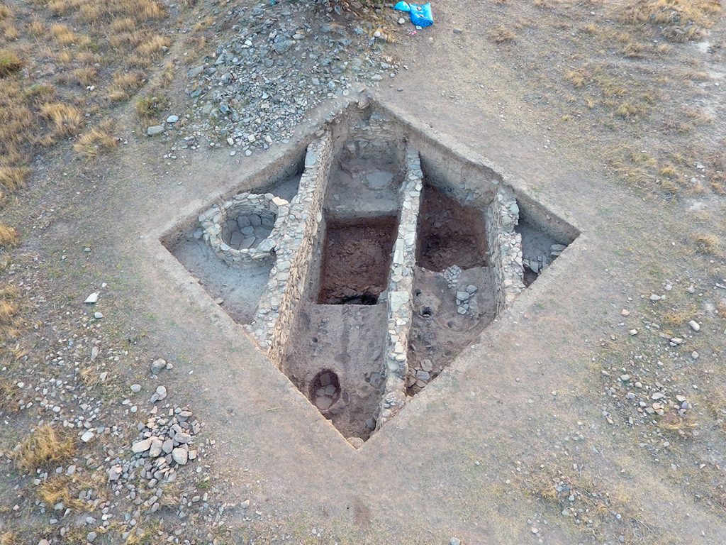
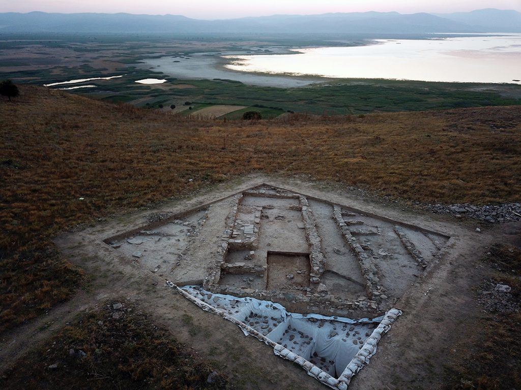
A key innovation of the Kaymakçı Archaeological Project (KAP) in developing the KAP Recording System in 2014 was its process of recording archaeological excavation in volumetric, 3D detail. Adopting a digital photogrammetric approach that leveraged quickly advancing Structure from Motion (SfM) processing via Agisoft software, field methods intend to enable highly accurate spatial documentation of excavation units (“spatial contexts”) using only digital tools. This means that time-consuming positional measurements using tape measures, string levels, and the like—not to mention pencil and paper—are unnecessary while in the field, because they can be calculated on the fly and whenever necessary from the fully digitized record. Subsequent recombination of the top and bottom surfaces of each excavation unit into an encapsulated volumetric entity—a time-consuming process in itself—allows the visualization of the original archaeological record in all its volumetric detail, enabling its virtual reconfiguration and re-excavation, turning the well-known archaeological trope “excavation is destruction” into “excavation is digitization.”

Remote Sensing

Since the inception of our research in the region, we have actively engaged in non-invasive approaches to understanding regional landscapes and individual sites. From historical aerial photographs (HAPs) from the mid-twentieth century and relatively low-resolution Landsat satellites to high-resolution multispectral QuickBird (now Maxar) and Planet satellites, we use images from above to help guide ground-truthing, ground-based work. Since 2013, unmanned aerial vehicles (UAVs), or drones, have enabled even higher-resolution imagery production and have enabled fine-scale topographic mapping — or microtopographic modeling – as well. Non-invasive subsurface prospection since 2007 has tested a variety of methods, including magnetometry, electromagnetic conductivity, magnetic susceptibility, ground-penetrating radar, electrical resistance tomography, and resistivity. Ongoing work focuses on the last of these methods, which continues to produce the best results for Kaymakçı’s specific conditions, revealing the locations of walls and other features with sub-meter precision.

Regional Interactions

To know a region, to experience a place is an integral part of how archaeologists participate in presenting cultural and natural heritage. Since our work began with the Central Lydia Archaeological Survey (CLAS), we’ve invested a lot in how archaeologists may be part of this perspective. We focus on positive outcomes, seeing communities as integral participants in achieving wider goals to understand, to present, and to preserve the region’s resources.

To get out and see places is extremely important. Here you meet people, you enjoy the views, and you understand what it feels like to have the wind at your back or the heat of the mid-day sun on your face, and you know the urgency of rushing to take cover from sudden thunderstorms.

To engage with people of all ages and their perspectives on where they live, watercolor and ebru (“marbling”) workshops brought community members together to explore local cultural and natural heritage through art. Art allows creative approaches to individual perspectives, and such workshops are nice opportunities for community gatherings. The natural and cultural foci of these workshops included local archaeology, landscapes, and, especially, the birds of the Marmara Lake basin.

Related projects focused on exploring the full trajectory of food production, preparation, marketing, and consumption. A later continuation of similar work took form in the SOFRA Project.

This earlier work led to the first-ever “field to table” dinner in the heart of Bin Tepe.

In 2012 CLAS proposed a selection of bike routes through Bin Tepe with different levels of difficulty for bikers of differing experience. We tested the routes, prepared maps, and submitted the concept to the Ministry of Culture and Tourism. This innovative concept may finally be coming to fruition: in 2025 it was proposed to be adopted and adapted as part of the “Heritage for the Future” project (Geleceği Miras Projesi); happily it also complements the ongoing nomination process to inscribe The Ancient City of Sardis and the Lydian Tumuli of Bin Tepe on the UNESCO World Heritage list, also supported by members of Gygaia Projects. We are very pleased by this recognition!

More recently, we’ve expanded our approach to getting out and around the Marmara Lake Basin to enjoy nature-culture spheres. In 2020 we proposed to the Gölmarmara Kaymakamlık a selection of hiking routes that connect the Asphodel Research center to the primary Bronze Age sites that surround the lake basin. It is the beginnings of a “Lydian Way” akin to the well-known “Lycian Way”!

Landscapes

When the Central Lydia Archaeological Survey (CLAS) began, the backbone of the research focused first and foremost on the concept of landscape – a holistic vision of place-making by those inhabiting this region. Change over time, from conceptual understandings to the physical transformation of the landscape, has resulted in shifting ideas for how communities referred to concepts of home and territory. From settled communities to transhumance, rich narratives of the ebbing and flowing of human heritage define this region. From the forests and lakes of the Bozdağ Mountain range, the vast Gediz River plain, the various rivers (Gediz and Alaşehir), the extensive Lake Marmara, and the uplands of the western and northern mountain ranges, our holistic interest continues to be the layers of legacies embodied across these landscapes.

Digital Recording & Database

From the beginning of survey work in 2005 to present excavation work, we have always strived to remain at the forefront of developing, cutting-edge technologies that can transform the ways archaeology is practiced and the archaeological record is interpreted and presented. Efforts began during survey work with handheld GNSS, digital photography, Geographic Information Systems, and database integrations, and subsequently transitioned to “paperless” solutions, including tablet recording of field data, whether from pedestrian field survey, geophysical survey, or excavation.
In 2014, we continued this work with the debut of a holistic digital recording solution for Kaymakçı: the KAP Recording System. Leveraging the connectivity provided by a solar-powered point-to-point network spanning several kilometers, a centralized PostgreSQL database stores data input via a combination of MS Access forms, bespoke Android apps for field and laboratory photography, and GNSS equipment. While the hardware and software that supports the system has been updated and modified slightly over the years, the primary architecture of the system endures, providing the foundation for the integrated workflows that define our teamwork.

Excavations at Kaymakçı

The Kaymakçı Archaeological Project began in 2014 with aims of conducting excavations and related research activities at and around Kaymakçı, a Middle and Late Bronze Age site located overlooking the western shore of Lake Marmara. Kaymakçı consists of a fortified citadel as well as dispersed extramural settlement and other remains. It is the largest known site of its period in the Gediz River valley and must have been a significant regional capital. The excavation of Kaymakçı promises gains for both the scientific knowledge of second-millennium BCE central western Anatolia and its links to the Aegean and Anatolian worlds. Geophysical prospection, excavations, and conservation and restoration activities are revealing and preserving the site’s architecture while an international team of scholars and students study material and environmental evidence to shed light on the ancient communities of Kaymakçı and the world they inhabited.

The Site

The citadel of Kaymakçı is located on top of a ridge of mica-schist bedrock around 140 meters above the level of Lake Marmara. With its main occupational phase dating to the Middle and Late Bronze Age periods, Kaymakçı represents not only the largest of the six contemporary citadels in the Marmara Lake basin discovered in the course of the Central Lydia Archaeological Survey (CLAS), but also, with its 8.6 ha enclosed space, the largest second-millennium BCE citadel in western Anatolia known to date. Based on both its archaeological evidence and the historical geography of western Anatolia as reconstructed from Hittite textual sources, Kaymakçı is one of the most likely candidates to be the capital of the LBA kingdom of the Seha River Land.

The first several years of excavations have focused on the three primary components of the citadel: the fortification system (areas 81.551 and 95.555); the inner citadel and surrounding slopes (areas 93.545, 97.541, and 98.531), and the southern terrace (areas 99.526 and 108.523/109.523). Based on identified ceramic and/or architectural phases, current understandings of the second-millennium BCE chronology of the citadel differentiate a limited occupation during the MBA (represented by ceramics alone at present) from more intensive phases of LBA occupation that are further divided into an earlier LB 1 phase (17th to 15th centuries BCE) and a later LB 2 phase (14th–13th centuries BCE). Limited ceramic collections may represent either terminal Late Bronze or very early Iron Age activities at the site, after which time it appears to have been thoroughly abandoned.

Ongoing excavations within and future excavations outside the citadel are hoped to shed more light on the mystery of Kaymakçı’s abandonment – induced from human-derived or environmental conditions or a combination of the two – and may illuminate also the full extent the site in extramural settlement and cemetery areas up the ridge, on the slopes of the ridge, and along the lakeshore.


Excavation Areas

This 9 x 9-meter excavation area is located along the fortification system in the northwestern-most part of the citadel. Excavations aiming to confirm geophysical results and explore the date and style of fortifications. Large bastion-like features with 2-meter wide walls, already visible in geophysical results, were built here in the local LB 2 phase, strengthening the fortifications in this otherwise vulnerable location.

This 11 x 11-meter excavation area is located on the western slope of the inner citadel, just southeast of a wide circuit wall that defines the core of the site. Excavations aim to explore the hypothesis that sloped areas of Kaymakçı’s citadel may contain better preserved remains dating to the site’s latest phases. Excavations to date reveal several phases of building and living activity above bedrock, dating between the local MB and LB 2 phases.

This L-shaped area consisting of a 9 x 29-meter rectangle and 9 x 9-meter addition, are located along the northern fortifications of the citadel. Excavations aimed to test geophysical results suggestive of a gate structure. Several phases of building and living activity are attested in the area, including the original construction of the 2-meter wide LB fortification wall and subsequent LB modifications, including several buildings and a possible gateway.

This 19 x 19-meter excavation area is situated in the uppermost, almond-shaped terrace of the inner citadel of Kaymakçı. Excavations aiming to determine the date and function of this this most-protected space of the citadel have revealed its 1.5-meter wide circuit wall and a large, seemingly open space occupied by at least 16 semi-subterranean circular features. Built using a combination of cut bedrock and drywall techniques, these were likely used originally as grain silos or other storage facilities and were emptied and filled with secondary deposits over the course of the local LB 1 and LB 2 phases.

Excavation of this 19 x 19-meter area located on the lower, outer terrace of the inner citadel of Kaymakçı aims to explore the date and function of this area of the inner citadel and have revealed semi-subterranean storage features similar to those unearthed in other areas of the site, as well as at least three building complexes situated opposite a narrow corridor and open courtyard. The buildings are internally articulated into smaller rooms, some of which are paved with flagstones, and include installations such as ovens/hearths and large pithoi, or storage jars. Ceramics retrieved from stratified layers suggest a period of use spanning the local LB 1 and LB 2 phases.

This 9 x 9-meter area is located on the southern, lower slope of the inner citadel, near its junction with the southern terrace. Excavations aim to test geophysical results and explore the date and use of a large building complex. Excavations to date have revealed a roughly square space abutted by several smaller walled spaces probably used for storage purposes during the local LB 1 and LB 2 phases.

This 9 x 9-meter area is located near the southwester edge of the Kaymakçı’s southern terrace. Aiming to elucidate geophysical results showing the clearly delineated walls of a building complex, excavations here were continued down to bedrock and represent the fullest LB sequence of activities recovered to date. Early LB 1 fills and other evidence suggest initial use for open-area activities. By the LB 1-2 transition, the area was built up with elongated buildings and continued to be used for mixed domestic, household industry, and storage purposes over several subphases.

Excavation of this 19 x 19-meter area located in center of Kaymakçı’s southern terrace aims to explore geophysical results suggestive of the area’s “urban” character, with streets and alleys dividing blocks of building complexes. Revealed at the southwestern corner of the area, a wide pebble-paved street appears to connect the outer fortifications with the inner citadel. Immediately northeast of and abutting the street are at least three long and rectilinear building complexes separated by narrow alleys. The occupational sequence is similar to that of 99.526: the earliest levels show traces of open-air activities and the following LB 2 phases are characterized by large architectural complexes of mixed domestic, household industry, and storage uses.